North Florida

Resilience System


You are here

NFL DRI - Emergency Management

Primary tabs

This working group is focused on discussions about emergency management.

The mission of this working group is to focus on discussions about emergency management.

Members

Albert Gomez Kathy Gilbeaux mdmcdonald MDMcDonald_me_com

Email address for group

nfl_dri_emergency_management@m.resiliencesystem.org

'Everyone Would Have Left': Putting Lessons From Hurricane Michael To Work


A boat moved by Hurricane Michael rests near a canal in May in Mexico Beach, Fla. Seven months after the hurricane made landfall, the town is still littered with heavily damaged or destroyed homes and businesses.  Scott Olson/Getty Images

npr.org - by Greg Allen - June 7, 2019

As another hurricane season begins, emergency managers and other officials throughout the Southeast and along the Gulf Coast are applying lessons they learned last year during Hurricane Michael. Those lessons include how they conduct evacuations . . .

 . . . we're going to start seeing a lot of things change . . . 

 . . . Among those likely changes: how people prepare for storms, how many evacuate and how strong new construction on Florida's Panhandle will need to be to survive hurricanes like Michael.

(CLICK HERE - READ COMPLETE ARTICLE)


Country / Region Tags: 
Problem, Solution, SitRep, or ?: 

Map - Hurricane Michael Partner's Brief - American Red Cross

https://arcg.is/015nii

For Damage Reports - Menu item 5 is the Disaster Assessment map.  When the map opens, another menu appears.
Choose DR 748-19 for Florida only.  You can then scroll in to see information for each county.

The numbers on the sides of the map show the total number of damaged homes on the screen in each category.  Due to a change in the DA system, you must add the columns on the right and left together for the totals. 


Country / Region Tags: 
Problem, Solution, SitRep, or ?: 

How Flood Control Officials Plan To Fix Area Floodplain Maps

Graphic of Texas shows the updated rainfall values in inches that define certain extreme events, such as the 100-year storm. Courtesy of NOAA

CLICK HERE - ENLARGED TEXAS MAP (1 page .PDF file)

New topographic and predictive rainfall data means more people in Harris County will be mapped in floodplains.

houstonpublicmedia.org - by Davis Land - November 26, 2018

When Hurricane Harvey left so much of Houston underwater, it highlighted a problem that’s been getting worse for years: Harris County’s existing floodplain maps just don’t work.

In the year since the historic storm, flood control officials have promised to change that, and they already had plans to redo the maps, but new data on the geography of the area and the amount of rainfall forecasters expect in the future means the new maps could look drastically different.

It’s crucial the maps are done right, as people are using the maps, meant to set flood insurance premiums, for more than they are intended . . . 

Country / Region Tags: 
Problem, Solution, SitRep, or ?: 

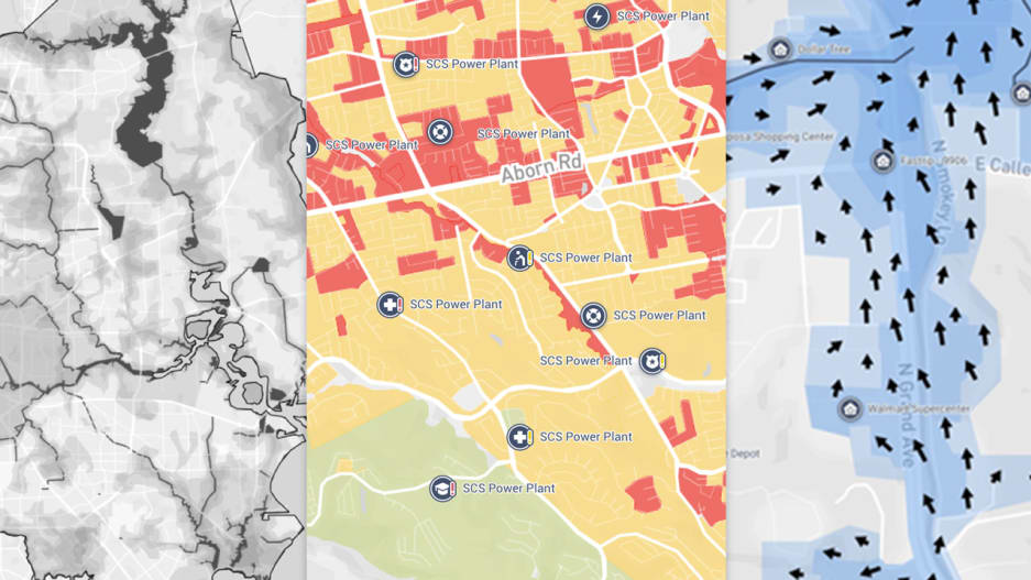
One Concern Uses AI to Streamline Disaster Relief Efforts


Image: One Concern

fastcompany.com - by Katharine Schwab - November 15, 2018

 . . . One Concern is launching a machine learning platform that provides cities with specialized maps to help emergency crews decide where to focus their efforts in a flood. The maps update in real-time based on data about where water is flowing to estimate where people need help the most. It’s the latest in a wave of AI-powered tools aimed at helping cities prepare for an era of severe, and increasingly frequent, disasters.

(CLICK HERE - READ COMPLETE ARTICLE)

---------------------------------------------------------

Our platform provides unprecedented situational awareness and actionable insights for decision-makers.

Country / Region Tags: 
Problem, Solution, SitRep, or ?: 

FEMA Flood Maps Ignore Climate Change, and Homeowners Are Paying the Price


The flood maps don’t factor in sea level rise or changes in extreme weather, and many are years out of date. In Mexico Beach, 'minimal-risk' homes were swept away.

insideclimatenews.org - by James Bruggers - November 1, 2018

The official map laid it out for more than 200 homes within the community of Mexico Beach, Florida: the federal government had characterized their flooding risks as minimal, despite their near-beachfront locations.

That meant for them there were no requirements to buy flood insurance, and local residents say many did not.

When Hurricane Michael and its 155-mile-per-hour winds slammed into the town on Oct. 10, with a storm surge of perhaps 19 feet, the result was devastation. An analysis by coastal geologists from Western Carolina University has found that 70 percent of the homes were demolished. Another 10 percent were severely damaged.

Country / Region Tags: 
Problem, Solution, SitRep, or ?: 

Fort Walton Beach Medical Center

Fort Walton Beach Medical Center has DMAT Delta-1 team and Louisiana Strike Team 5 working with them.  Their base of operations is set up in big tents within the hospital courtyard.  They are transporting patients by helicopters and ambulance from Bay County area medical facilities.

If you have a healthcare related concern and cannot get help, Consult-A-Nurse is a free service designed to help answer healthcare questions. You can contact their nurses 24 hours a day by phone at (866) 442-2362.

If you are trying to get in touch with a loved one that has been transported, please call the Patient Reunification Line at 844-582-2350 . . .

https://www.facebook.com/FWBMC/

Country / Region Tags: 
Problem, Solution, SitRep, or ?: 
howdy folks